
ISSN (0970-2083)
ISSN (0970-2083)
| Natsir Abduh1*, Gufran Darma Dirawan2* and Ahmad Rifqi Atsrib2 Post Graduate Program, Makassar State University, Makassar, South Sulawesi, Indonesia |
| Corresponding Author's: Natsir Abduh, E-mail: abduhnatsir@gmail.com Gufran Darma Dirawan, E-mail: gufrandarma@yahoo.com |
| Received: 2 June, 2015; Accepted: 15 July, 2015 |
Visit for more related articles at Journal of Industrial Pollution Control
The objective of this study was to analyze the level of noise and air pollution in a designated ecoairport. The parameter of measured : Noise level measurement using a sound level meter, carried out in the span of one hour at 5 points, namely on the apron, waiting room-2 departure gate, gate departure lounge-5, arrivals lounge area and basement area. Moreover the indicators of air pollution instrument was measuring the level of air pollution conducted in the laboratory by Sulfur Dioxide (SO2), Nitrogen Dioxide (NO2) and Carbon Monoxide (CO). Measurements were done in a span of one hour at 7 points, namely on the apron, the departure gate lounge area 2, the area of the departure lounge gate 5, the arrival of the southern area, the northern part of the arrival area, basement, ground parking lot area. Results of the analysis of the average measurements showed that the noise level was 72.53 dBA, while for the analysis of air pollution level measurement parameters, i.e sulfur dioxide (SO2) is 13.748 μg/ Nm3, Nitrogen Dioxide (NO2) is 18.650 μg/Nm3 and Carbon Monoxide (CO) is 25.942 μg/Nm3. Based on these results the Sultan Hasanuddin eco-airpot due to the Measured values does not pass the quality standard threshold levels of noise and air pollution levels. However, little improvment in air and noise quality can make it eg-airport.
Keywords |
| Sodium adsorption ratio (SAR), Groundwater pollution, Geostatistics |
INTRODUCTION |
| Groundwater forms one of the primary resources for development activities. In recent times, there has been tremendous demand for fresh water due to population growth and intensive agricultural activities. Groundwater quality is the physical and chemical characterization of groundwater, which measures its suitability for human and animal consumption, irrigation and other aims. Irrigation water quality is generally judged by some determining factors such as sodium absorption ratio (SAR), soluble sodium percentage (SSP), residual sodium carbonate (RSC), and electrical conductance (EC) (Richards, 1954). In the study used SAR for determination of waterground quality. |
| A high SAR concentration in the water leads to the formation of saline soil and the higher concentration of sodium leads to development of alkali soil. Irrigation water could be a source of excess sodium in the soil solution and hence it should be evaluated for this hazard (Sayyed and Wagh, 2011). The sodium or alkali hazards (in using water for irrigation) is calculated by determining the absolute and relative concentrations of cations and is expressed in terms of Sodium adsorption ratio (SAR) which is a simple method to evaluate the danger of high-sodium water (Richards, 1954). Usually SAR less than 3.0 will not be a threat to vegetation while SAR greater than 12.0 is considered sodic and threatens the survival of vegetation by increasing soil swelling (dispersion) and reducing soil permeability (Kuipers et al., 2004). Also recently one of the methods use Geostatistical methods in GIS. The GIS is an effective tool in the estimation of the spatial distribution of environmental variables (Rabah et al., 2011). Interpolation can be undertaken utilizing simple mathematical models (e.g., inverse distance weighting, trend surface analysis and splines), or more complex models (e.g., geostatistical methods, such as kriging) (Negreiros et al., 2011). The purpose of this study is to employ geostatistical analysis (IDW) for prediction of SAR in north of Darab city in south of Iran. Also relationship between SAR and Na, Ca and Mg were determined by Multi-layer perceptron (MLR). |
MATERIALS AND METHODS |
Study area |
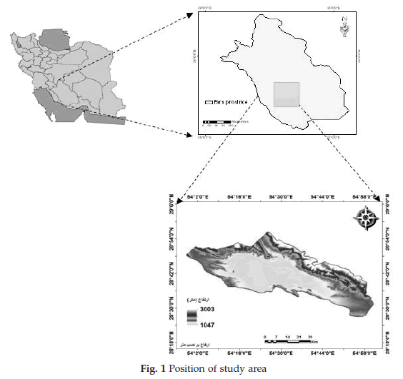
| This study was located in north of Darab city in south of Iran. The study area located between 28° 57’ to 28° 06’ northern latitude and 53° 27’ to 55° 55’ eastern longitude (Figure 1). |
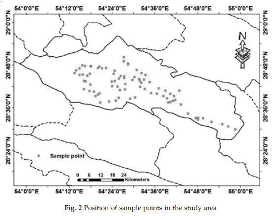
| In order to investigate of groundwater quality used 82 sample points that show in Figure 2. |
Inverse Distance Weighting (IDW) |
| The inverse-distance weighted procedure is versatile, easy to program and understand, and is fairly accurate under a wide range of conditions (Lam, 1983). Using this method, the property at each unknown location for which a solution is sought is given by: |
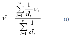 |
| Where as :υ: value to be estimated, vi = known value and di..., dn= distances from the n data points to the point estimated n |
Sodium Adsorption Ratio (SAR) |
| The suitability of the groundwater for irrigation from the present area of study was judged by determining the SAR value and they were categorized under different classes. Sodium adsorption ratio (SAR) was computed by using the following formula: |
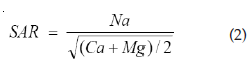 |
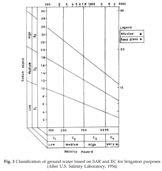
| Sodium adsorption ratio is the proportion of sodium to calcium and magnesium, which effect the availability of the water to the crop. Classification of ground water based on SAR and EC for Irrigation purposes show in the Figure 3. |
Multiple regression models |
| The general form of the regression equations is n according to Eq. 3: |
| Y=A0 + A1X1 +A2X2 + … +bnXn (3) |
| Where Y is the dependent variable, A0 is the intercept, A1. . .bn are regression coefficients, and X1– Xn are independent variables referring to basic groundwater properties. |
| The general purpose of multiple regressions is to learn more about the relationship between several independent or predictor variables and a dependent or criterion variable. The contents of available SAR was made related to Ca, Na and Mg properties by constructing regression equations using the stepwise procedure of SPSS (2002). |
RESULTS |
SAR analysis |
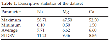
| In order to prediction availability of SAR used Na, Mg and Ca that descriptive statistics show in Table 1. According to Table 1 the maximum value of Na, Mg and Ca are 58.71, 47.50 and 52.50 respectively. |
 |
Prediction of SAR by using geostatistic analysis |
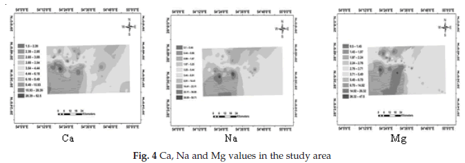
| In the study area used from IDW. IDW interpolation produces show in Figure 4. The lowest output in Ca, Na and Mg are 1.5, 0.1 and 0.5 respectively while the maximum output in Ca, Na and Mg are 52.5, 58.7 and 47.5 respectively. |
 |
 |
 |
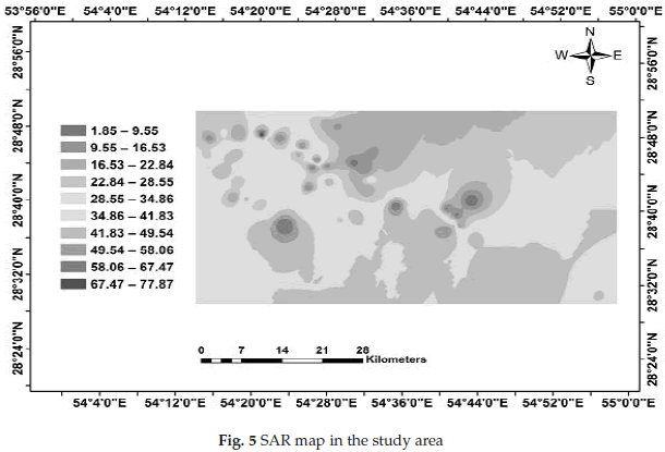
| In the finally according to Eq. 2 SAR map was preparing that show in Figure 5. |
Relationships between available SAR with groundwater properties |
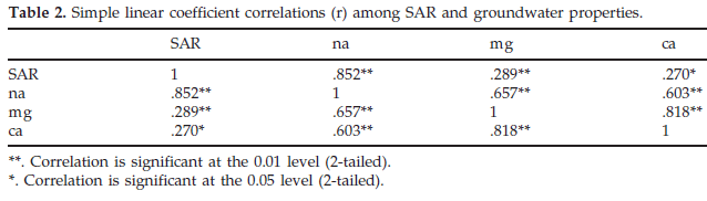
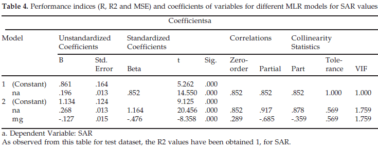
| The calculated simple linear correlation coefficients (r) between SAR and independent variables are summarized in Table 2. It was found that there is a positive and significant correlation between SAR and Na (0.852**). |
Prediction of SAR by using MLR |
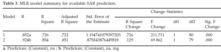
| For predicting SAR through MLR model, first the most important input variables were selected using stepwise method, and then linear interaction term of these basic groundwater properties were investigated. Results indicated that Na and Mg were the most important properties determining SAR parameters (Tables 3 and 4). |
 |
 |
 |
 |
CONCLUSION |
| The aim of this study was to provide SAR and mapping methods that are in common for prediction of SAR. Our case study showed that the IDW method is more accurate for predicting the spatial patterns of SAR. Also in this study MLR was used for predicted SAR. Also relationship between SAR and Na, Ca and Mg were determined by Multi-layer perceptron (MLR). The results show that the most SAR value is located in the south of the study area. Also MLR was found that there is a positive and significant correlation between SAR and Na (0.852**). |
 |
References |
|
Copyright © 2026 Research and Reviews, All Rights Reserved