
ISSN (0970-2083)
ISSN (0970-2083)
1*School of Mechanical and Building Sciences, VIT University, Vellore, Tamil Nadu
2**Ramky Enviro Ltd, Hyderabad, AP., India
Received date 29 January, 2015;Accepted date 10 April, 2015
Visit for more related articles at Journal of Industrial Pollution Control
Global changes impacting on the use of water resources are the reality and recognizing that urbanization will exert a greater impact on human activity compared to climate change, at least up until 2050, requires urgent action. Unavailability of land mainly due to urbanization has led to the considerable increase in number of townships being constructed. With the rate of increase in the number of townships and the development of resources in these townships following opposite directions, planned management and judicial use of existing resources becomes critical. The availability of water resource is one major area of concern considering the drastic increase in the water demand in townships. Integrated Water Resource Management is one of the best ways to ensure water sustainability, for a township it becomes equally important to manage the resources which are limited and excessive amount of waste water being generated from usage. Water demand for the township was projected based on population to estimate the supply required in long term. Thus waste water generated also plays a crucial role as it can be used as resource for recycling and recharging. The water balance of the township is further enhanced with the integrated resource management approach.
Industrial water, Waste water, Integrated water management, Townships
Fresh, accessible water is a scarce and unevenly distributed resource, not matching patterns of human development. Over half the world’s population faces water scarcity because it plays vital role in the sustenance of all life. Water scarcity acts as a limiting factor in the economic and social development- (Narasimhan, 2008).Global changes impacting on the use of water resources are the reality and recognizing that urbanization will exert a greater impact on human activity compared to climate change, at least up until 2050, requires urgent action. In 2011, in India nearly 31% of the population (377 million people) resided in urban areas and by 2030 it is expected to become almost 50%.Urbanization in India is faced with two pronged challenges. On one hand the pressure of the ever-growing existing cities coupled with the colossal challenge of providing them with basic infrastructure and services. But there is also little denying the fact that the civic authorities and government have been trying to make ends meet as far as the quality, adequacy and availability of basic services like water and sewage. The ever-expanding water demand driven by world’s growing population and economy, combined with the impacts of climate change, are already making water scarcity a stark reality in many parts of the world. While the water situation in India is not so attractive as of now, reforms have begun to shape and success and this would encourage private investors. With the increased involvement of the private sector, there will be a need for efficient water and waste water management to improve operating efficiency levels. Planning, development and management of water resources for diverse uses may help to generate financial resources, introduce corporate management and improve service efficiency and accountability of users. There is an increased realization of shift from water resources development to water resource management by restructuring and strengthening existing institutions for enhanced service delivery and resource sustainability. Water deficit is becoming a serious constraint in Indian cities. National Institute of Urban Affairs (NIUA, 2005) concludes that 56 per cent of metropolitan, class-I and class-II cities are dependent on groundwater either fully or partially. Cities are now drawing water from sources hundreds of kilometers away, giving rise to conflicts with the existing users of that water. In buildings, water is used intensively during both construction and operational phases. A large part of water use in buildings can be attributed to the operational phase of buildings, where it is directly related to lifestyle of the occupants. The average water consumption in India has been calculated as 135 liters’ per capita per day (as prescribed by the Central Public Health and Environmental Engineering Organization or CPHEEO).
Study on water poverty in urban India by the Mumbai-based Tata Institute of Social Sciences (TISS, 2008) states that at the household level, bathing consumes the highest amount of water. Together, in all the seven cities it surveyed it was found that bathing accounts for about 28 per cent of the total water used. Consumption in toilets (20 percent), washing clothes (19 per cent) and washing utensils (16 percent) follows. On an average, less than 10 per cent of the total water in a household is used for drinking and cooking.
Urbanization is one of the most critical issues governing the production and use of wastewater. It will need more attention than climate change up until 2050 (OECD, 2012). Large urban areas, but particularly unplanned smaller urban centers present the biggest threat, but also the biggest opportunity for introduction of sustainable approaches to managing resources. There have been many catastrophic impacts of poor wastewater management, but by and large they are unseen or, as is often the case, occur downstream from the places where the pollution originated. In many high-density urban settings, inadequate wastewater and surface water management results in significant intra-urban differences in relation to environmental health impacts. The current approach to curative rather than preventative strategies is not only more resource intensive but also inadequate.
With increase in population, there will be an increase in stress on sanitation and wastewater disposal system. Gupta et al., (2004) predicted that recyclable wastewater will meet 15% of total water requirement in 2050.Wastewater is an under-utilized resource. Reuse or recycling can combine an effective environmental and health protection strategy with the recovery of water, nutrients and energy. In water scarce developing countries, grey water reuse in schools, hospitals and government institutions is proving to be an essential alternate water resource to fresh ground, surface or rainwater supplies (Godfrey et al., 2006). Studies from the Middle-East and India for example indicate that grey water systems have water saving of between 3.4% - 33.4% per annum (Al- Jayyousie, 2003).
About Study area
Bangalore (Rural) District consists of eight Taluks, viz Ramanagaram, Channapatna, Magadi, Kanakapur, Devanahalli, Doddaballapur, Hosakote and Nelamangala. Devanahalli taluk is one amongst the eight Taluks in the District.It has a geographical area of 448.12 sq. km, 8 per cent of that of the District total area. The Taluk enjoys salubrious climate and free from extremes. It receives rainfall from southwest monsoon from June to September, the northeast monsoon from October to November. The soil of the Taluk is red sandy soil derived from peninsular genesis, granites and laterites. The soil is red to brownish in color, shallow to fairly deep shallow; loamy to sandy loamy in texture intermixed with fairly large amounts of coarse gravel and pebbles.
The Taluk is mainly dependent on ground water for agriculture, industrial and domestic purposes. The net irrigated area is 8587 hectares; of which 1400 hectares is irrigated by surface water (tanks, canals, etc.) forming 16% to the net irrigated area and remaining 84% is irrigated through ground water (wells, borewells). Water supply to Devanahalli town is augmented through bore well sources, for both industrial and domestic purposes. The study area is a proposed township which is located in Devanahalli taluk, between 13°12’38.37” North latitude and 77°39’36.59”East Longitude.
This study is based on Field test data and secondary data collected from various sources. The base data was obtained by various field tests conducted in the study area. The secondary data was obtained from CPHEEO, Central Groundwater Board, Natural Resource Data Management Center, Department of Mines and Geology.
Primary data includes the data collected by field tests for identification and quantification of the water resources in the township. The main aim of this work was to identify measures for water sustainability in the township, which involves various aspects such as: population, water demand, water availability, resource identification, waste water generation, waste water recycling.
Integrated Water Resource Management is one of the best ways to ensure water sustainability, for a township it becomes equally important to manage the resources which are limited and the waste water being generated from usage. The population for the township was forecasted and the water demand for the projected population was estimated as per CPHEEO Water Supply Standards and (NBC, 2005). The Yield of the existing bore wells in the township was identified using Single well Step drawdown Method and the safe yield of the bore wells was determined.
The Groundwater recharge potential estimation was done both by field test and from the secondary data collected. The groundwater recharge potential estimation was done in the field by using Infiltration Test. The vertical seepage of the water into the soil contributes to the aquifer recharge, which serves as the basis for the test. The actual infiltration volume was considered as 50 % of the total infiltration volume in the township due to lack of detention time, runoff loses, evaporation losses and alteration in the intact condition of the soil. The Infiltration volume was also estimated using the secondary data considering normal rainfall in the township catchment area with Infiltration volume as 15% of the total volume of rainfall water received. The recharge potential estimation will provide a brief idea about the stage of ground water development in the township.
The resource yield and the water demand showed a gap hence identification of new water resource was required. Spontaneous polarization or self-potential methods involve measurement of electric potentials developed locally in the Earth by electro-chemical activity, electro filtration activity, or both. For water investigation potentials generated by water moving through a porous medium (streaming potential) is important. Measurements of these potentials have been used to locate leaks in reservoirs and canals (Ogilvy et al., 1969). Spontaneous potentials generally are no larger than a few tens of millivolts but in some places may reach a few hundred millivolts. Relatively simple equipment can be used to measure the potentials.
The new identified points were used to determine the expected yield; the expected yield of the new points was taken as an average of the determined safe yield of the existing bore wells. Roof top rainwater harvesting estimation was done using the secondary data collected.
Soil profile information was generated using Shallow Electric Resistivity Method. Shallow Schlumberger array (four electrode configuration) was used to generate the soil strata information. The strata information up to 50 meters was obtained by measuring the resistivity of the rocks. It consists of four electrodes; two inner electrodes and two outer electrodes inserted into the ground. The inner electrodes were at a distance (mn/2) and outer electrodes distance (ab/ 2) from the midpoint. A DC source is used to pass current through the external electrodes into the soil and current is measured using the ammeter connected to the external circuit. . The soil strata, mainly the rocks based on the characteristic nature provides resistance to the flow of current passed by the external electrodes. The resistance is measured as voltage in the inner circuit. Resistance for both direct and reverse current at each point is measured as Rd and Rr. The reverse and direct current is sent to increase the accuracy of potential measured as average of the potential for Rd and Rr was taken.
Wastewater generation estimation was done based on population, water consumption by various activities. Dual collection system of grey water and black water separately was proposed and the treatment was scheme was based on typical low load grey water and black water characteristics from residential and commercial sections. The low load grey water collected separately was treated using slow sand filter and was recycled to meet the flushing requirement of the residential section of the township. Black water was collected and treated to be used for meeting commercial flushing requirement and landscaping activities. Water balancing was done for the township and integrated water, waste water management scheme was proposed to provide sustainability to the resources and usage in the township.
Data Integration
The area details of the buildings in the residential and commercial sections were collected. The water resource consumption is based on the population of the township; hence the population forecast was done for both residential and commercial sections. Other primary data was collected by conducting various field tests and the secondary data was also used in estimations.
Population Forecast
In residential area the population forecast was done considering 6 member families in the total area of the buildings. For the commercial section population forecast was done considering 1 person per 200 square feet for the total area of the buildings. Water demand estimations were made based on 135 LPCD water supply requirements as shown in Table 1.

Table 1. Population Forecast and Water demand Estimation for the Township
Bore well Yield Determination
There were 8 number of existing bore wells in the township; single well step drawdown method was used to determine the yield of the bore wells. The effective drawdown was determined using the equation (1)
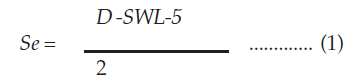
Where, Se = Effective drawdown
D = Total water depth
SWL = Static water level
The water level fluctuation due to seasonal variation is considered when calculating the effective yield. The step drawdown pumping at variable discharge is shown in (Fig. 1).

Fig. 1 Drawdown of bore wells at variable discharge ratemeter/min
The discharge and (maximum drawdown/discharge) graph is used to determine the slope and intercept as shown in (Fig 2).

Fig. 2 Ratio of Maximum drawdown by Discharge
The optimum yield for different bore wells was estimated using the equation (2)
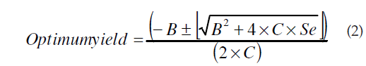
Where, B = Intercept
C = Slope
C = Slope Se = Effective drawdown
Soil Infiltration Capacity Determination
It was carried out to determine the infiltration capacity of the soil in the township. Both vertical and horizontal seepage takes place but only vertical seepage is considered as it is responsible for the aquifer recharge. The water infiltration into the soil was measured against time and based on the infiltration value the infiltration or ground water recharge volume was estimated. The infiltration rate for the township was taken as an average of test values done at different locations, is shown in (Fig. 3)

Fig. 3 Infiltration rate for the water in townshipcm/hr.
Rainfall Infiltration Method: this method is based on the primary and secondary data collected. The infiltration volume in the township catchment area was estimated using equation (3)
Totalvolum =AreaxNormalra inf all x35.32x1000x28.32 .....(3)
The Infiltration volume was estimated as 15% of the total volume of water received by the catchment area.
Identification of new potential bore well points
The projected water demand for the township could not be met by using the existing resources in the township, hence identification of new potential bore well points was carried out.
Spontaneous Polarization Test:New potential bore well points identification was done by using Spontaneous polarization test, which measures the earth’s natural potential due to inflow and outflow of water in and out of aquifer. The potential measured against distance was plotted to identify 7 new potential points as shown in (Fig. 4)

Fig. 4 Earth’s Natural Potential millivolts/meter
Roof top rainwater runoff estimation was developed using the primary and secondary data. The rainwater collection from roof top will enhance the water sustainability in the township as shown in Table 2.

Table 2. Roof top Run off Estimation for Residential Buildings
Determination of Soil profile
Soil profiling helps to analyze and understand the soil structure and distribution within different depth ranges. It would help to identify locations and adopt appropriate methods to enhance the water sustainability.
Shallow Electric Resistivity Method: Shallow Schlumberger array (four electrode configuration) was used to generate the soil strata information. The strata information upto 50 meters was obtained by measuring the resistivity of the rocks.
Waste water generation estimation
Total waste water generated was estimated from the population and the typical percentage of water usage for various daily activities as shown in table 3.

Table 3. Waste water generation Estimation
Low load waste water and black water generation estimation was done to assess the possibility of dual collection system and recycling of waste water to meet the flushing and landscaping demands of the township (Table 4).

Table 4. Residential Low load Grey water generation
The determination of optimum yield from each bore well is used to determine the depth at which pump should be fixed such that it will remain submerged even after continuous pumping for 10 hours. The safe yield for continuous pumping of 10 hours was estimated for each bore well ie., 70 % for yield test done in rainy period as shown in Table 5.

Table 5. Estimation of Safe yield of existing bore wells
Table 4 gives the yield of water source available at the township and helps to identify the gap between the forecasted water demand and the availability of water. The yield of the existing bore well was estimated as 0.5 MLD as compared to the water demand being 2.4 MLD for the township.
The Infiltration volume for the township is an essential parameter that determines the ground water recharge potential of the township. The Infiltration rate was determined to be 0.101cm/s ie. 1.46m/day, this was used to estimate the actual infiltration volume (Table 6). Actual infiltration volume was taken as 50% of total infiltration volume calculated due to losses by evaporation, runoff and detention time.

Table 6. Estimation of Actual Infiltration volume from Field Infiltration Test
For comparison infiltration volume was estimated by the Rainfall Infiltration Method using the secondary data. It shows the fluctuation in the infiltration volume that can occur in the real case scenario as shown in Table 7.

Table 7. Estimation of Infiltration volume from Rainfall Infiltration Method
7 new potential bore well points were identified using the SP Test (table 8). Hence the expected yield of new bore well points was estimated using the average yield values of the existing bore wells.

Table 8. Estimation of Expected Yield for new bore well points
Overall Drinking water balance was developed for the township including existing, newly identified water resources and roof runoff as shown in Table 9. Waste water management plan including dual collection system and recycling for various activities was developed for the township as shown in (Fig. 5)

Table 9. Estimation of Overall Water Balance for the Township

Fig. 5 Waste water Management Flowchart
Figure 4 represents the proportion of waste water generated as low load, high load and black water and Collection of a low load and black water separately for treatment. The treatment is based on their typical characteristics for recycling.
Integrated water and wastewater flow scheme was developed which is shown in (Fig. 6).

Fig. 6 Integrated Water and Waste water Management Flowchart
The limited availability of resources and the high water demand in the townships has been the major concern. Hence to ensure water sustainability in the township, integrated water and waste water management provides an effective strategy. According to integrated management principle wastewater should also be seen as a source and recycling an essential measure to boost sustainability.
The problem of water scarcity, waste water and unavailability of land for individual residents does enhance the growth of newly developing townships in many parts of India. All these townships aim at providing all the facilities required for all age group people within permissible distance. As the complexity of townships is increasing the management of water resources, waste water is looked upon with prime importance.
This work provides is aimed at proper water management, waste water and solid waste management in townships. The population projection of the township was used to determine the water demand. The water sustainability studies were carried to identify the availability of existing water sources in the township. The water balance was obtained for the township using different methods to identify the fluctuations that might occur in the water balance. Basically followed field yield test showed a deficit in water supply; hence various methods like Spontaneous polarization and Electrical resistivity were used to identify new water sources. The qualitative analysis was carried out and treatment scheme was proposed.
The waste generation estimations were done and two different management schemes were proposed for the management of waste water generated. First method was dual collection system with low load grey water and black water from residents being collected separately and treated. Since Grey water typically has low concentration of contaminants slow sand filter based treatment scheme was proposed. Second method consists of collection of black water in residential and commercial waste water separately and treatment. The flushing water demand of 30% and 60% for residential and commercial respectively was proposed to be met by the treated grey water and waste water. Integrated water and waste water management provides an effective and efficient management strategy to promote sustainability in the township.
Copyright © 2026 Research and Reviews, All Rights Reserved